https://www.jpl.nasa.gov/news/news.php?feature=6584Páginas

2/3/12

How are Global Warming and the Gulf Stream Connected?

About.com-Environmental Issues


If melting glaciers deflect warm Gulf Stream, U.S. and Europe may freeze
From Larry West, former About.com Guide
Dear EarthTalk: What is the issue with the Gulf Stream in relation to global warming? Could it really stop or disappear altogether? If so, what are the ramifications of this? 

Lynn Eytel, Clark Summit, PAPart of the Ocean Conveyor Belt—a great river of ocean water that traverses the saltwater sections of the globe—the Gulf Stream stretches from the Gulf of Mexico up the eastern seaboard of the United States, where it splits, one stream heading for Canada’s Atlantic coast and the other for northern Europe and Greenland. By taking warm water from the equatorial Pacific Ocean and carrying it into the colder North Atlantic, the Gulf Stream warms up the eastern United States and northwestern Europe by about five degrees Celsius (roughly nine degrees Fahrenheit), making those regions much more hospitable than they would be otherwise.
Melting Glaciers Could Disrupt Warm Gulf Stream Currents

Among the greatest fears scientists have about global warming is that it will cause the massive ice fields of Greenland and other locales at the northern end of the Gulf Stream to melt rapidly, sending surges of cold water into the ocean system and interrupting the flow of the Ocean Conveyor Belt. One doomsday scenario is that such an event would stop or disrupt the whole Ocean Conveyor Belt system, plunging
Western Europe into a new ice age without the benefit of the warmth delivered by the Gulf Stream.
Gulf Stream May Affect Climate Change Worldwide

“The possibility exists that a disruption of the Atlantic currents might have implications far beyond a colder northwest
Europe, perhaps bringing dramatic climatic changes to the entire planet,” says Bill McGuire, a geophysical hazards professor at University College London’s Benfield Hazard Research Centre.
Gulf Stream Disruption Could Freeze Europe and North America

Computer models simulating ocean-atmosphere climate dynamics indicate that the
North Atlantic region would cool between three and five degrees Celsius if Conveyor circulation were totally disrupted. “It would produce winters twice as cold as the worst winters on record in the eastern United States in the past century,” says Robert Gagosian of the Woods Hole Oceanographic Institution.
Gulf Stream Linked to Previous Temperature Changes

The slowing of the
Gulf Stream has been directly linked with dramatic regional cooling before, says McGuire. “Just 10,000 years ago, during a climatic cold snap known as the Younger Dryas, the current was severely weakened, causing northern European temperatures to fall by as much as 10 degrees Fahrenheit,” he says. And 10,000 years earlier—at the height of the last ice age when most of northwestern Europe was a frozen wasteland—the Gulf Stream had just two-thirds of the strength it has now.
Could Weakened Gulf Stream Help Offset Global Warming?

A less dramatic prediction sees the
Gulf Stream slowing down but not stopping entirely, causing the east coast of North America and northwestern Europe to suffer only minor winter temperature dips. And some scientists even put forth the optimistic hypothesis that the cooling effects of a weakened Gulf Stream could actually help offset the higher temperatures otherwise caused by global warming.
Global Warming: A Planetary Experiment

To McGuire, these uncertainties underscore that fact that
 human-induced global warming is “nothing more nor less than a great planetary experiment, many of the outcomes of which we cannot predict.” Whether or not we can trim our addiction to fossil fuels might just be the determining factor in whether global warming wreaks havoc around the world, or just causes us minor annoyances.
GOT AN ENVIRONMENTAL QUESTION? Send it to: EarthTalk, c/o E/The Environmental Magazine, P.O. Box
5098, Westport, CT 06881; submit it at:www.emagazine.com/earthtalk/thisweek/, or e-mail:
 earthtalk@emagazine.com.

9/2/12

Riesgo de cambios abruptos o irreversibles

IPCC

El calentamiento antropógeno podría dar lugar a efectos abruptos o irreversibles, en función de la tasa y magnitud del cambio climático proyectado. {GTII 12.619.319.4RRP}
A escalas de tiempo decenales, se suele considerar que un cambio climático abrupto está asociado a cambios en la circulación oceánica. Además, a escalas de tiempo superiores, los cambios del manto de hielo y de los ecosistemas podrían desempeñar también algún papel. Si llegase a acaecer un cambio climático abrupto en gran escala, sus efectos podrían ser de gran magnitud (véase el Tema 5.2). {GTI 8.710.310.7; GTII 4.419.3}
La pérdida parcial de los mantos de hielo en tierras polares y/o la dilatación térmica del agua marina podría ocasionar, a escalas de tiempo muy prolongadas, aumentos de nivel del mar de varios metros, importantes alteraciones de las líneas costeras e inundaciones en extensiones bajas, y sus efectos serían máximos en los deltas pluviales e islas bajas. Los modelos actuales indican que esos cambios tendrían lugar en escalas de tiempo muy prolongadas (milenios) si subsistiera un aumento de la temperatura mundial de entre 1,9 y 4,6°C (con respecto a la era preindustrial). No hay que excluir aumentos rápidos de nivel del mar a escalas de tiempo seculares. {IDS 3.2.3; GTI 6.410.7; GTII 19.3RRP}
El cambio climático acarreará probablemente algunos efectos irreversibles. Con un grado de confianza medio, entre un 20% y un 30% aproximadamente de las especies estudiadas hasta la fecha estarían probablemente expuestas a un mayor riesgo de extinción si el aumento del calentamiento mundial excediese, en promedio, de entre 1,5 y 2,5°C (respecto del período 1980-1999). De sobrepasar los 3,5°C, proyecciones de los modelos predicen un nivel de extinciones cuantioso (entre un 40% y un 70% de las especies con- sideradas) en todo el mundo. {GTII 4.4Figura RRP.2}
Las actuales simulaciones mediante modelos indican que es muy probable que la circulación de renuevo meridional (CRM) del Océano Atlántico se desacelere durante el siglo XXI; las temperaturas de esa región, pese a todo, aumentarían. Es muy improbable que la CRM experimente una fuerte transición abrupta durante el siglo XXI. No es posible evaluar con un grado de confianza suficiente los cambios de la CRM a más largo plazo. {GTI 10.310.7; GTII Figura, Tabla RT.5RRP.2}
Los impactos de gran escala y los cambios persistentes de la CRM alterarán probablemente la productividad de los ecosistemas marinos, las pesquerías, la incorporación de CO2 por el océano, las concentraciones de oxígeno en el océano y la vegetación terrestre. Las alteraciones de la incorporación de CO2 por la tierra y por el océano podrían producir un retroefecto sobre el sistema climático. {GTII 12.619.3Figura RRP.2}

8/2/12

NASA Finds Russian Runoff Freshening Canadian Arctic


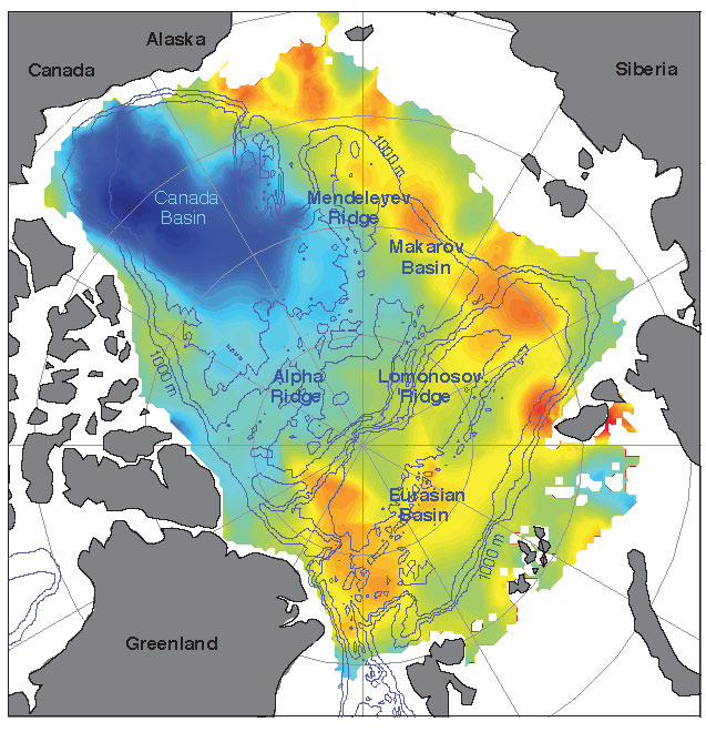
Increasing freshwater on the U.S. and Canadian side of the Arctic from 2005 to 2008 is balanced by decreasing freshwater on the Russian side, so that on average the Arctic did not have more freshwater. Here blue represents maximum freshwater increases and the yellows and oranges represent maximum freshwater decreases. Credit: University of Washington 
› Larger view

NASA
January 04, 2012
PASADENA, Calif. - A new NASA and University of Washington study allays concerns that melting Arctic sea ice could be increasing the amount of freshwater in the Arctic enough to have an impact on the global "ocean conveyor belt" that redistributes heat around our planet.

Lead author and oceanographer Jamie Morison of the University of Washington's Applied Physics Laboratory in Seattle, and his team, detected a previously unknown redistribution of freshwater during the past decade from the Eurasian half of the Arctic Ocean to the Canadian half. Yet despite the redistribution, they found no change in the net amount of freshwater in the Arctic that might signal a change in the conveyor belt.

The team attributes the redistribution to an eastward shift in the path of Russian runoff through the Arctic Ocean, which is tied to an increase in the strength of the Northern Hemisphere's west-to-east atmospheric circulation, known as the Arctic Oscillation. The resulting counterclockwise winds changed the direction of ocean circulation, diverting upper-ocean freshwater from Russian rivers away from the Arctic's Eurasian Basin, between Russia and Greenland, to the Beaufort Sea in the Canada Basin bordered by the United States and Canada. The stronger Arctic Oscillation is associated with two decades of reduced atmospheric pressure over the Russian side of the Arctic. Results of the NASA- and National Science Foundation-funded study are published Jan. 5 in the journal Nature.

Between 2003 and 2008, the resulting redistribution of freshwater was equivalent to adding 10 feet (3 meters) of freshwater over the central Beaufort Sea.

The freshwater changes were seen between 2005 and 2008 by combining ocean bottom pressure, or mass, data from NASA's Gravity Recovery and Climate Experiment satellites with ocean height data from NASA's ICESat satellite. By calculating the difference between the two sets of measurements, the team was able to map changes in freshwater content over the entire Arctic Ocean, including regions where direct water sample measurements are not available.

"Knowing the pathways of freshwater is important to understanding global climate because freshwater protects sea ice by helping create a strongly stratified cold layer between the ice and warmer, saltier water below that comes into the Arctic from the Atlantic Ocean," said Morison. "The reduction in freshwater entering the Eurasian Basin resulting from the Arctic Oscillation change could contribute to sea ice declines in that part of the Arctic."

"Changes in the volume and extent of Arctic sea ice in recent years have focused attention on melting ice," said co-author and senior research scientist Ron Kwok of NASA's Jet Propulsion Laboratory, Pasadena, Calif., which manages Grace for NASA. "The Grace and ICESat data allow us to now examine the impacts of widespread changes in ocean circulation."

Kwok said on whole, Arctic Ocean salinity is similar to what it was in the past, but the Eurasian Basin has become more saline, and the Canada Basin has freshened. In the Beaufort Sea, the water is the freshest it's been in 50 years of record keeping, with only a tiny fraction of that freshwater originating from melting ice and the vast majority coming from Russian river water.

The Beaufort Sea stores more freshwater when an atmospheric pressure system called the Beaufort High strengthens, driving a counterclockwise wind pattern. Consequently, it has been argued that the primary cause of freshening is a strengthening of the Beaufort High, but salinity began to decline early in the 1990s, when the Beaufort High relaxed and the counterclockwise Arctic Oscillation pattern increased.

"We discovered a pathway that allows Russian river runoff to feed the Beaufort gyre," Kwok said. "The Beaufort High is important, but so are the hemispheric-scale effects of the Arctic Oscillation."

"To better understand climate-related changes in sea ice and the Arctic overall, climate models need to more accurately represent the Arctic Oscillation's low pressure and counterclockwise circulation on the Russian side of the Arctic Ocean," Morison added.

For more on Grace and ICESat, visit: http://www.csr.utexas.edu/grace/ , http://grace.jpl.nasa.gov/ , andhttp://icesat.gsfc.nasa.gov/icesat/ .

JPL is managed for NASA by the California Institute of Technology in Pasadena.
Alan Buis 818-354-0474
Jet Propulsion Laboratory, Pasadena, Calif.
Alan.buis@jpl.nasa.gov

Sandra Hines 206-543-2580
University of Washington, Seattle
shines@uw.edu


2012-002 

6/2/12

El frío dispara las muertes en Italia y congela los vuelos en Heathrow


EL PAIS. 5/02/2012

La ola de frío siberiano no ha echado el freno y sigue su avance a marchas forzadas hacia la franja occidental de Europa. La cifra de muertos por el primer arreón del temporal en el este del continente sobrepasa ya con creces los 250, la mayoría en Ucrania, donde temperaturas de hasta 33 grados bajo cero han causado la muerte de más de 120 personas, muchas de ellas en la calle por congelación o hipotermia. El fallecimiento de otras ocho personas eleva a más de medio centenar los muertos en Polonia; mientras que el balance de víctimas en Rusia alcanza los 60, en Bulgaría, 16, en Hungría, 6, y al menos 34 en Rumania, donde la lluvia helada ha empezado a caer sobre el país y las ventas de los comercios han experimentado un incremento del 140%, informa Raúl Sánchez Costa.


Con menos agresividad y, sobre todo, menos pérdidas de vidas, el frío se extiende por la Europa occidental e incluso el norte del Magreb. El manto blanco caído durante el fin de semana en Bosnia, con una intensidad sin igual en décadas, ha acumulado en algunas partes del país balcánico hasta dos metros de nieve. La capital, Sarajevo, ha declarado el estado de emergencia, mientras un centenar de localidades permanecen aisladas por el frente de frío. Las autoridades bosnias se han visto obligadas a usar helicópteros para repartir comida o trasladar a los enfermos. En la vecina Serbia, unas 70.000 personas no tienen acceso a los servicios básicos. La nieve caída sobre la costa adriática de Croacia, que ha requerido del Ejército para las labores de limpieza, ha causado la muerte de al menos tres personas.


18 muertes en Italia

Más al oeste, el paisaje espectacular que han inmortalizado las cámaras en el corazón del turismo italiano, Roma, nevado hasta la coronilla, no ha aliviado los problemas que el frío está ocasionando en toda Italia. La ola siberiana ha causado la muerte ya de 18 personas en tan solo 48 horas, ha obligado a cortar algunos servicios de transporte y a interrumpir en algunas zonas el suministro eléctrico. Al menos 80.000 familias en el centro y sur del país se encuentran sin luz.


Según el servicio meteorológico de la Aeronáutica Militar italiana las previsiones para este domingo indican nevadas en todo el centro del país en las regiones de Emilia Romagna (que ayer declaró el estado de emergencia), Las Marcas, Umbría, la Toscana y Los Abruzos. Asimismo, la nieve también hará su aparición en la región sureña de Calabria por encima de los 400 metros. Más de 80.000 familias de Lacio, Molise, Campania y Los Abruzos siguen sin suministro eléctrico.


Hasta el momento, se han registrado al menos 18 muertes debido al mal tiempo, entre ellas la de un hombre cuyo cadáver fue localizado en la localidad de Ostia, cercana a Roma, en la misma zona donde ayer murió una mujer de origen ucranio.


El frío intenso sigue azotando a toda Francia, donde ya han muerto cinco personas en las últimas 48 horas, informa Miguel Mora. Cuatro de ellos eran personas sin techo que no habían querido o podido encontrar refugio. La quinta víctima es un niño de 12 años que el sábado cayó a un estanque helado en la zona de Los Vosgos.


75 departamentos (provincias) han declarado la alerta naranja por gran frío o por nieve y aguanieve, y la entrada del frente atlántico ha dejado las primeras nevadas del invierno en Normandía. También París, donde hoy el termómetro baja hasta los 5 bajo cero, ha amanecido con un manto blanco de unos cinco centímetros, pero es en el este del país donde se registran las temperaturas más bajas. Los meteorólogos prevén una leve mejoría para esta tarde y un regreso del frío intenso para mañana.


En algunas zonas del territorio continental ha habido problemas con el suministro de luz y gas, ya que se han registrado los picos más altos de consumo energético en mucho tiempo. Para el lunes está previsto que la compañía EDF alcance un récord histórico de consumo. El ministro de Economía, François Baroin, ha afirmado hoy que “de momento, la situación está bajo control”, aunque ha admitido que en Bretaña y el sudeste del país hay “algunos problemas de red” que podrían implicar una reducción de la potencia eléctrica sin mayor trascendencia.


En Reino Unido, la nieve ha cubierto de blanco gran parte del país con hasta 16 centímetros de espesor en algunas áreas urbanas. La mitad de los vuelos de Heathrow, el principal aeropuerto europeo, han sido cancelados por el temporal (una decena, por el momento, con salida o destino el aeródromo de El Prat) mientras que el tráfico de trenes y suburbanos ha sufrido también interrupciones. La nevada ha caído con especial intensidad durante el sábado en Escocia, Gales y el norte de Inglaterra. Se espera que el temporal amaine durante el domingo, aunque el servicio meteorológico ha alertado a los ciudadanos de la formación de capas de hielo sobre el piso.


La ola de frío ha alcanzado en su avance hacia el Oeste también el norte de África dejando una estampa poco habitual. Las copas de las palmeras en Argelia están bañadas del manto blanco que ha formado la nevada caída en las últimas horas, la primera que ven los argelinos en los últimos ocho años.

1/2/12

Will the Gulf Stream slow down, freezing the UK and northern Europe?


Sunlight shines on a Gulf Stream eddy in the north Atlantic, as seen from space. Photograph: Nasa/Corbis


 THE GUARDIAN
The Gulf Stream and North Atlantic Drift – which are part of the Atlantic thermohaline circulation – bring warm water, and with it warm air, from the tropical Atlantic to northern Europe. This helps keep the UK several degrees warmer than it would otherwise be.
Although this system is unlikely to pack up entirely, the IPCC deems a slowdown of it "very likely" over the next century. The reason is that increasing rainfall and snow-melt across the Arctic and nearby land areas could send more freshwater into the north Atlantic, pinching off part of the warm current. The best guess from the most sophisticated computer models is that the circulation might slow by 10% to 50% over the next century, if greenhouse gas emissions continue unabated. If this happens, the expected climate warming might be nearly erased across the United Kingdom and diminished across many other parts of Europe. However, summers could still be warmer and more drought-prone across the UK and Europe than they are now.
In any case, the impacts would be much smaller – and would take much longer to play out – than the scenario dramatised in the film The Day After Tomorrow. Although evidence shows that the thermohaline circulation has ground to a halt more than once in climate history, it's believed that this process takes at least a few years to play out, and sometimes many decades, rather than the few days portrayed in the film.
This is an extract from The Rough Guide to Climate Change by Robert Henson.

27/1/12

¿CUANTA AGUA DULCE SE HA AÑADIDO AL ATLANTICO NORTE EN DECADAS RECIENTES?

El contínuo endulzamiento del Atlántico Norte ralentizará el Transportador durante el siglo 21


Por :

Ruth Curry del Woods Hole Oceanographic Institution (WHOI)

Cecilie Mauritzen del Norwegian Meteorological Institute
 
Desde finales de la década de los 60 grandes regiones del Atlántico Norte se han ido renovando con el deshielo de los glaciares así como con el incremento de las precipitaciones, ambos hechos asociados con el Calentamiento Global. En el mismo período de tiempo, los registros de salinidad muestran que una gran cantidad de hielo marino extra y agua dulce del Artico han fluido al Atlántico Norte. Pero, hasta ahora no se conocían las cantidades reales y la proporción de acumulación de agua dulce.

En un artículo publicado el 17 de Junio en Science, Ruth Curry del Woods Hole Oceanographic Institution (WHOI) y Cecilie Mauritzen del Norwegian Meteorological Institute han cuantificado por vez primera cuanta augua dulce adicional han causado los cambios en la salinidad observados en el Atlántico Norte, como concierne ello a la circulación atlántica y donde se ha almacenado el agua dulce. Ellas han descubierto que los patrones de acumulación de agua fresca en las cuatro décadas de finales del siglo XX sugieren que en un siglo podría darse un freno en la Banda Transportadora Atlántica que transfiere calor al Atlántico Norte, aunque el futuro impacto del Calentamiento Global y de la fusión de los glaciares invitan a la cautela en estas previsiones.

Curry y Mauritzen analizaron los datos recogidos en el Atlántico Norte, entre Labrador, Groelandia y el norte de Europa durante 55 años para mostrar los cambios de temperatura, salinidad y densidad que se han sucedido. Estimaron, para períodos de cinco años consecutivos, cuanta agua dulce hubo de añadirse o quitarse para dar cuenta de los cambios de salinidad observados desde 1953 hasta el año 2002. Hicieron un mapa de distribución del agua dulce, capa por capa, para determinar donde estaba aumentando y como afectaba ello a la densidad del océano. Y entonces usaron las proporciones encontradas para calcular cuanto se tardaría en alcanzar los umbrales que afectarian a la parte de la circulación oceánica conducida por la densidad.

En un año medio, cerca de 5.000 kilometers (km) cúbicos de agua dulce fluyen desde el Artico hasta el Atlántico Norte a traves de pasadizos al este y oeste de Groelandia. Las investigadoras estimaron que unos 19.000 Km cúbicos adicionales se añadieron y diluyeron en el Atlántico Norte durante el período 1965-1995. La mitad de ellos entró en el sistema a finales de los 60 elevando la cantidad a 7.000 Km3 al año, e incrementando un 40% el flujo de agua dulce. Como comparación, el caudal de salida del Mississippi es de 5.000 Km3 al año mientras el Amazonas descarga de 5.000 a 6.000 Km3 anualmente.

Curry encontró que en los años 50 e inicios de los 60, los registros muestran que la salinidad aumenta en las cubetas subpolares mientras que el atlántico norte los cambios eran realmente pequeños. Sin embargo, entre 1970 y 1995 en ambas área crece la cantidad de agua dulce. El evento más llamativo del período ocurre al principio de la década de los 70 y es conocido como “Gran Anomalia de la Salinidad”. A finales de los 60 una fuerte llegada de agua dulce entra en los mares nórdicos y mueve la Corriente de Groelandia Oriental hacia el Sur. Este evento contribuye con 10.000 Km3 de agua dulce nueva que se mezcló entre Labrador y la Cubeta de Iminger, moviéndose a profundidades medias alrededor del Atlántico Norte.


Diversas avenidas de agua dulce y hielo parecen llegar desde el Artico en la década de los 80 y 90. Alrededor del 80% de los 19.000 km3 de agua dulce nueva volcada al Atlántico Norte entre 1965 y 1995 se ha depositado en las cubetas subpolares con una superficie dos veces mayor que el mar nórdico. La cantidad de agua dulce involucrada sería el equivalente a una capa de tres metros cubriendo uniformemente el área de las cubetas subsolares y una de 1,8 metros cubriendo el mar nórdico.


El Mar Nordico ( localizado entre Islandia, Groelandia y Noruega ) ,el Labrador y la cubeta de Irminger son lugares donde se forman aguas frías y densas, un componente crítico de la Circulación Meridional ( MOV ) y parte de la cinta transportadora oceánica que lleva las aguas calientes superficiales desde los trópicos hacia el norte. A altas latitudes esta agua superficial se enfría (realizando el intercambio de calor con la atmósfera) y estas aguas densas se hunden y fluyen hacia el sur por el fondo del océano en un proceso que realimenta el movimiento del transportador.


El intercambio de calor que realiza el transportador contribuye a moderar los inviernos en latitudes altas , especialmente Islas Británicas y Escandinavia.


Una exceso de agua dulce altera la densidad del océano que conduce una parte de este sistema circulatorio, disminuyendo la cantidad de calor que es llevado hacia el norte, especialmente en áreas significativamente frías del Hemisferio Norte. Curry y Mauritzen indican que los cambios en la salinidad observados hasta la fecha no parecen haber cambiado la circulación oceánica ni el transporte de calor, pero esperan que un continuo endulzamiento del agua afecte al transporte oceánico en los próximos doscientos años.

“La precipitación y el escurrimiento de los ríos en latitudes altas ha aumentado”, dice Curry. “En la última década, se ha ido acumulando agua dulce en el Atlántico Norte, que es crítico en el transporte oceánico, y esto es algo que hay que tener en cuenta. El hielo de Groelandia es una espada de Damocles(*)”, dijo ella. “Esto es una cantidad enorme de agua dulce en contención que, si se fundiera, afectaría a la cabecera del transporte oceánico.”

Aproximadamente un tercio del MOV atlántico cruza la cordillera que se extiende de Groelandia a Escocia y que separa el Mar del Norte del Atlántico Norte. El intercambio de aguas entre el norte y el sur de la cordillera es controlado por un contraste entre la densidad oceánica que a profundidades de 200 a 800 m los mares nórdicos son mas densas que en las cubetas subpolares. Si añadimos agua dulce al océano, reducimos su densidad, quitando agua dulce o eliminando su salinidad, incrementamos la densidad. Así, una acumulación de agua dulce en el Mar del Norte hará que disminuya su densidad. El contraste de densidad Norte-Sur descenderá y el flujo que atraviesa la cordillera se ralentizará. Este flujo de agua densa y fria ha sido estrechamente monitorizada durante más una década con una serie de instrumentos sin que se hayan apreciado cambios significativos.

De los 19.000 Km3 de agua dulce adicional que se diluyeron en el Atlántico norte desde 1960, solamente una pequeña cantidad ( unos 4.000 km3 ) permanecen en el Mar del Norte y solo unos 2.500 Km3 permanecen en la capa crítica que alimenta el flujo sobre la cordillera de separación. Esta es la razón, según Curry, de que el endulzamiento no ha retardado todavía el flujo de agua. A la proporción observada, pues, haría falta un siglo para llegar a la cantidad crítica necesaria para ralentizar el flujo sobre la cordillera Groelandia-Escocia ( sobre unos 9.000 km3 según el estudio ) y cerca de dos para que la continua dilución lo parara. Las investigadoras concluyen que un cambio abrupto en la circulación oceánica no parece inminente.


Curry apunta que las incertidumbres permanecen al evaluar la posibilidad de interrupciones de la circulación , incluyendo futuros ratios del calentamiento global y deshielo. Muchas simulaciones por ordenador del calentamiento global, muestran incrementos de la precipitación y del escorrentio de los ríos en latitudes altas que llevan a un retardo del transporte Atlántico. Sólo un modelo de estudio disponible, asimismo, contiene una descripción de la interactividad con el hielo de Groelandia. El estancamiento del agua de deshielo, el derrumbe de una porción de hielo seguido por una ola del movimiento del glaciar o la lubricación de la base del glaciar por la fusión del hielo son todos los mecanismos que podrían inyectar el agua dulce necesaria en las capas críticas del Mar del Norte.


“Esto, ciertamente, hace que siga teniendo sentido monitorizar el hielo y los cambios atmosféricos conjuntamente”, dice Curry. “Dada la proyección para el siglo 21 en las concentraciones de gases invernaderos y de incremento de agua dulce en el norte oceánico, nosotros no podemos predecir un retardo en el transporte Atlántico en los siguientes 100 años. Quiero enfatizar que nosotras hablamos de acerca de escalas de tiempo en centurias para encontrar cambios en el transporte oceánico a traves de la cordillera Groelandia-Escocia. No sugerimos que la corriente del Golfo vaya a cerrarse.

¿Pequeña Edad de Hielo en vez de calentamiento global?

por Dr Theodor Landscheidt


Theodor Landscheidt (born in 1927 in Bremen, Germany, died on May 20, 2004) was an author, astrologer and amateur climatologist.[1]

In 1989, Landscheidt forecast a period of sunspot minima after 1990, accompanied by increased cold, with a stronger minimum and more intense cold which should peak in 2030, which he described as the "Landscheidt Minimum" . His work on solar cycles is cited by global warming skeptics [3] to argue that observed warming is not anthropogenic and will soon be reversed, based on an assumption that fluctuations in climate are controlled by solar activity.

In 1983 he founded and financed the Schroeter Institute for Research in Cycles of Solar Activity in Lilienthal, near Bremen. The Institute later moved with him to Nova Scotia, Canada.

In 2000, Landscheidt was a panelist at Rice University's Baker Institute for Public Policy Global Warming Conference


El análisis de la variable actividad solar en los últimos dos mil años indica que, contrariando a las especulaciones del IPCC acerca de un calentamiento global inducido por el hombre de 5,8°C en los próximos cien años, se espera un largo período de clima frío con su pico más frío hacia el año 2030. Se muestra que el mínimo del ciclo Gleissberg de 80 a 90 años de la actividad solar, coincidentes con períodos de climas fríos en la Tierra, están ligados de manera consistente a un ciclo de 83 años en el cambio de la fuerza rotatoria que impulsa el movimiento de rotación del Sol alrededor del centro de masa del sistema solar. Dado que el curso futuro de este ciclo, así como sus amplitudes pueden ser computadas, se puede ver que el mínimo Gleissberg del año 2030 y otro alrededor del 2200, serán del tipo del Mínimo Maunder, acompañados por un severo enfriamiento de la Tierra. Este pronóstico puede ser acertado ya que otros pronósticos a largo plazo del fenómeno climático, basados en el movimiento orbital cíclico del Sol, han resultado ser correctos - como por ejemplo la predicción de los últimos tres eventos de El Niño, años antes de su ocurrencia.

 
No necesitamos esperar hasta el 2030 para ver si la predicción del próximo Mínimo Gleissberg es correcta. Mucho antes de alcanzar el punto más bajo del desarrollo, debería hacerse manifiesta una tendencia declinante en la actividad solar y las temperaturas globales. El actual ciclo 23 de manchas solares, con su actividad considerablemente más débil, parece ser la primera indicación de la nueva tendencia, especialmente porque fue pronosticada en base a los ciclos de movimientos del Sol hacen ya dos décadas. En cuanto a la temperatura, sólo los períodos de El Niño deberían interrumpir la tendencia hacia abajo, pero hasta los Niños podrían hacerse menos frecuentes y fuertes.

Serie de tiempos de los extremos sin suavizar de los cambios en la fuerza rotatoria orbital del Sol dT/dt para los años 1.000 - 2250. Se observa que cada vez que la amplitud de un extremo negativo pasa por debajo del umbral inferior, indicado por la línea horizontal de rayas, esto coincide con un período de actividad solar excepcionalmente débil. Dos extremos negativos consecutivos que trasponen el umbral indican un Gran Mínimo, como los Mínimos Maunder (hacia 1670), Spoerer (1490), Wolf (1320), y Norman (1010), mientras que un único extremo por debajo del umbral va junto a eventos del tipo del Mínimo Dalton (1810 y 1170), no tan severos como los Grandes Mínimos. De manera que los Mínimos Gleissberg del 2030 y 2200 deberían ser del tipo Mínimo Maunder. Como el clima está estrechamente ligado a la actividad solar, las condiciones hacia el 2030 y 2200 deberían acercarse a las del nadir de la Pequeña Edad de Hielo del 1670. Como se explica en el texto, la hipótesis del IPCC de un calentamiento global inducido por el hombre no está en la línea de esta predicción basada exclusivamente en la actividad eruptiva del Sol. Los extraordinarios extremos positivos tienen una función similar en relación a períodos excepcionalmente calientes como el Óptimo Medieval y el período cálido moderno.

Western Arctic Ocean freshwater storage increased by wind-driven spin-up of the Beaufort Gyre

Katharine A. Giles, / Seymour W. Laxon, / Andy L. Ridout,/ Duncan J. Wingham / & Sheldon Bacon/ Affiliations Contributions Corresponding author

Nature Geoscience (2012) Letter
 doi:10.1038/ngeo1379 Received 01 March 2011 Accepted 29 December 2011 Published online 22 January 2012


The Arctic Ocean’s freshwater budget comprises contributions from river runoff, precipitation, evaporation, sea-ice and exchanges with the North Pacific and Atlantic1. More than 70,000 km3 of freshwater2 are stored in the upper layer of the Arctic Ocean, leading to low salinities in upper-layer Arctic sea water, separated by a strong halocline from warm, saline water beneath. Spatially and temporally limited observations show that the Arctic Ocean’s freshwater content has increased over the past few decades, predominantly in the west3, 4, 5. Models suggest that wind-driven convergence drives freshwater accumulation6. Here we use continuous satellite measurements between 1995 and 2010 to show that the dome in sea surface height associated with the western Arctic Beaufort Gyre has been steepening, indicating spin-up of the gyre. We find that the trend in wind field curl—a measure of spatial gradients in the wind that lead to water convergence or divergence—exhibits a corresponding spatial pattern, suggesting that wind-driven convergence controls freshwater variability. We estimate an increase in freshwater storage of 8,000±2,000 km3 in the western Arctic Ocean, in line with hydrographic observations4, 5, and conclude that a reversal in the wind field could lead to a spin-down of the Beaufort Gyre, and release of this freshwater to the Arctic Ocean.

Figures at a glance

15/1/12

NASA Finds Russian Runoff Freshening Canadian Arctic

01.04.12

PASADENA, Calif. - A new NASA and University of Washington study allays concerns that melting Arctic sea ice could be increasing the amount of freshwater in the Arctic enough to have an impact on the global "ocean conveyor belt" that redistributes heat around our planet.
Lead author and oceanographer Jamie Morison of the University of Washington's Applied Physics Laboratory in Seattle, and his team, detected a previously unknown redistribution of freshwater during the past decade from the Eurasian half of the Arctic Ocean to the Canadian half. Yet despite the redistribution, they found no change in the net amount of freshwater in the Arctic that might signal a change in the conveyor belt.
The team attributes the redistribution to an eastward shift in the path of Russian runoff through the Arctic Ocean, which is tied to an increase in the strength of the Northern Hemisphere's west-to-east atmospheric circulation, known as the Arctic Oscillation. The resulting counterclockwise winds changed the direction of ocean circulation, diverting upper-ocean freshwater from Russian rivers away from the Arctic's Eurasian Basin, between Russia and Greenland, to the Beaufort Sea in the Canada Basin bordered by the United States and Canada. The stronger Arctic Oscillation is associated with two decades of reduced atmospheric pressure over the Russian side of the Arctic. Results of the NASA- and National Science Foundation-funded study are published Jan. 5 in the journal Nature.
Between 2003 and 2008, the resulting redistribution of freshwater was equivalent to adding 10 feet (3 meters) of freshwater over the central Beaufort Sea.
The freshwater changes were seen between 2005 and 2008 by combining ocean bottom pressure, or mass, data from NASA's Gravity Recovery and Climate Experiment satellites with ocean height data from NASA's ICESat satellite. By calculating the difference between the two sets of measurements, the team was able to map changes in freshwater content over the entire Arctic Ocean, including regions where direct water sample measurements are not available.
"Knowing the pathways of freshwater is important to understanding global climate because freshwater protects sea ice by helping create a strongly stratified cold layer between the ice and warmer, saltier water below that comes into the Arctic from the Atlantic Ocean," said Morison. "The reduction in freshwater entering the Eurasian Basin resulting from the Arctic Oscillation change could contribute to sea ice declines in that part of the Arctic."
"Changes in the volume and extent of Arctic sea ice in recent years have focused attention on melting ice," said co-author and senior research scientist Ron Kwok of NASA's Jet Propulsion Laboratory, Pasadena, Calif., which manages Grace for NASA. "The Grace and ICESat data allow us to now examine the impacts of widespread changes in ocean circulation."
Kwok said on whole, Arctic Ocean salinity is similar to what it was in the past, but the Eurasian Basin has become more saline, and the Canada Basin has freshened. In the Beaufort Sea, the water is the freshest it's been in 50 years of record keeping, with only a tiny fraction of that freshwater originating from melting ice and the vast majority coming from Russian river water.
The Beaufort Sea stores more freshwater when an atmospheric pressure system called the Beaufort High strengthens, driving a counterclockwise wind pattern. Consequently, it has been argued that the primary cause of freshening is a strengthening of the Beaufort High, but salinity began to decline early in the 1990s, when the Beaufort High relaxed and the counterclockwise Arctic Oscillation pattern increased.
"We discovered a pathway that allows Russian river runoff to feed the Beaufort gyre," Kwok said. "The Beaufort High is important, but so are the hemispheric-scale effects of the Arctic Oscillation."
"To better understand climate-related changes in sea ice and the Arctic overall, climate models need to more accurately represent the Arctic Oscillation's low pressure and counterclockwise circulation on the Russian side of the Arctic Ocean," Morison added.

For more on Grace and ICESat, visit:

JPL is managed for NASA by the California Institute of Technology in Pasadena.
Alan Buis 818-354-0474
Jet Propulsion Laboratory, Pasadena, Calif.Alan.buis@jpl.nasa.gov
Sandra Hines 206-543-2580

University of Washington, Seattle

shines@uw.edu 


Increasing freshwater on the U.S. and Canadian side of the Arctic from 2005 to 2008 is balanced by decreasing freshwater on the Russian side, so that on average the Arctic did not have more freshwater. Here blue represents maximum freshwater increases and the yellows and oranges represent maximum freshwater decreases. Credit: University of Washington 

Red arrows show the new path of Russian river water into the Canada Basin. The previous freshwater pathway - across the Eurasian Basin toward Greenland and the Atlantic - was altered by atmospheric conditions created by the Arctic Oscillation. Credit: University of Washington 


An instrument about to be dropped through an opening in the ice to the seafloor will record ocean bottom pressure to compare with similar data recorded by NASA's GRACE satellites. Data from GRACE, ICESat and actual water samples led to the discovery of a new pathway of freshwater in the Arctic. Credit: C. Peralta-Ferriz/UW Applied Physics Laboratory